11/14/2010
Another Cub Scout hike, 3 familes in total this time. We headed up to Lake Solitude, then up to the cliffs and had a snack and back down. Didn't summit, didn't plan to - lake and cliffs were more than enough of a destination for the kids.
Can't find pictures atm...

Sunday, November 14, 2010
Saturday, October 23, 2010
Purgatory Falls
10/23/2010
I led my cub scout den on a short trip to Purgatory Falls as one of our Go See It! achievements. We had 6 families in all and stopped at Upper Falls and had a picnic lunch down in the kitchen. Then continued to middle falls, looked for a geocache w/o luck and headed back north. Stopped at upper falls again and showed the kids the beanpot and lowered each down inside.
Just Alex and I for our family on this one.
Great short hike and kids seemed to enjoy it!

 | |
| Alex in the Beanpot |
Sunday, September 12, 2010
Mt Monadnock - September 12, 2010
I was looking for something closer to home and a bit easier than the 4000 footers we have done recently so I chose Monadnock, although it certainly is no slouch of a mountain either. I have done Monadnock a few times before and with the exception of a couple winter hikes, it is so crowded that personally I find it not very enjoyable. So I picked a different side of the mountain that I had not hiked before and hoped the trails were also less traveled. The weather also called for afternoon showers so between the two we might just make it up without 5,000 other people.
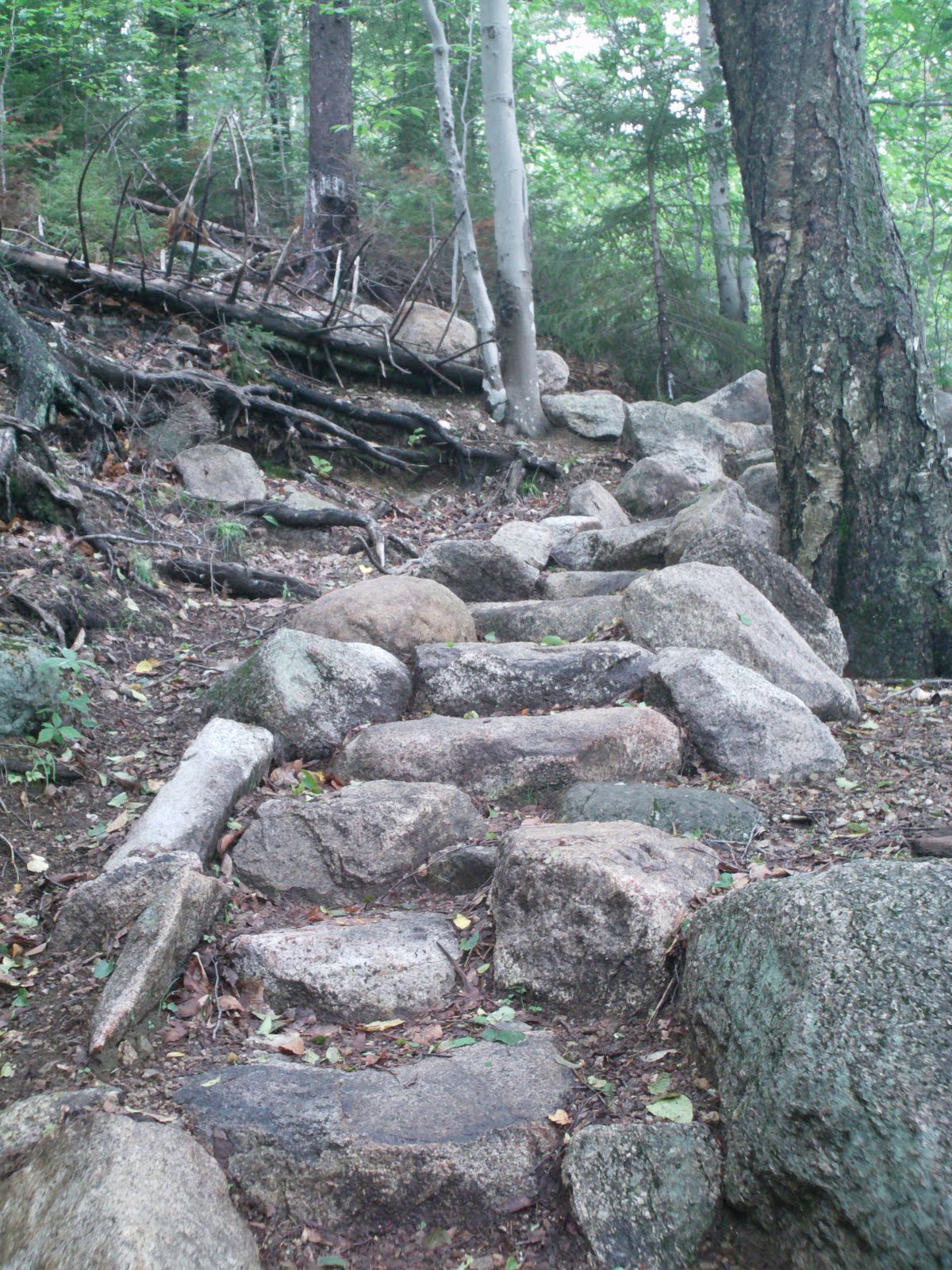
We headed up the Old Halfway House trail which parallels a dirt road that leads to a private residence. We heard many people walking up the road but only saw one other person on the trail. To me, if I am going hiking I would rather be on a trail in the woods than on a dirt road but to each their own, glad I was the minority. This section is only about a mile long and an easy gentle grade to the site of the old Halfway House.
Alex was not so sure if he wanted to go on the hike when we started driving but I said lets just get there and then decide. When we saw the mountain completely covered in clouds he wanted to go up inside the clouds and quickly changed his mind. Along the hike we were debating what the clouds felt like. Alex thought they would feel like cotton balls but I was betting on sandpaper. Alex was sure he was right. Since I had not been on this side of the mountain before I was not sure in what locations I should have been able to see it or not. But when we reached the HalfWay house site I figured that would have been a good place, we were getting very close to the bottom of the clouds now. We stopped here for a little while and explored the area before heading of Fairy Spring Trail to Mt Rosa. We saw a few people here, but not many, not many at all for Monadnock.
It was getting cold and misty so we were going to decide to continue on or turn back once we got to Rosa. Along the way it looked like it was really going to rain and we were getting hungry when we came across this cave/rock overhang which was large enough for both of us to fit in so in we crawled and had our lunch. While eating the sky opened up and it rained, the clouds also came through and we saw all the mist blow past us. After the rain died down a little we headed back out with rain gear on. We got to the summit of Rosa w/o issue but still could not see Monadnock as we were just about in the clouds at that point. We both felt good so we headed up the Smith Summit Trail.
As we went up Smith Summit Trail the weather started to clear and we started to get a little warm so the rain gear went back into the packs. We even started to get a glimpse of the summit and people scrambling around on the rocks. The trail got much more interesting at this point climbing up over rocks and above the tree level. I had Alex lead the whole way having him practice finding which way the trail went by spotting the cairns or the white trail blazes painted on the rocks. A couple times he couldn't see the next cairn, but that was mostly because he was too short to see up over some other rocks. Did a good job navigating up!
We reached the summit and then we saw all the people. Probably 15 or so, but up until this point was a pretty quiet hike. It was also extremely windy which Alex got a kick out of. And very chilly, we didn't have winter hats or gloves but would have worn them if we had. Couldn't have been too cold as when we were up there some man in at least his 50s came running, yes running, up the mountain wearing nothing but a pair of shorts and some sneakers. Stopped at the summit and put the shirt on he had tied around the waist. 30 seconds later off he went running back down. Crazy guy if you ask me! But I hope I am in that good of shape when I am his age - I am not in that good of shape now and I am probably at least 20 years younger. We explored the summit but the wind was very intense so we found a sheltered area to rest and had our snack before descending down the White Arrow Trail.


I tried to avoid the popular trails, but at the summit - there are no light hiked trails! So we headed down the White Arrow trail and were passed by many people heading down and many people heading up. Pretty steep and lots of climbing down rocks. I usually always have Alex in front of me so he can set his own pace and so I can keep an eye on him. But when it gets steep like it was here and we are descending I go first and have him wait while I go a little ways so I can catch him if he slips. And it paid off on this trip! Down he went and I caught him just before (well maybe just after) he landed face first on some rocks. Got his hands out in front of him and didn't hit too hard but I'm sure all the people that passed us and then some could hear the cries. No cuts, scrapes or bruises I think the tears were from shock more than anything else. Alex got over it pretty quickly but wanted to take a long break right there so we did. Just prior to the fall he, as always, was talking up a storm non stop. I kept telling him to stop talking until we got to a flat spot as the talking distracts him from climbing down the steep parts. It wasn't 2 seconds after I said this that he fell (while talking talking talking). Well after that, he quiet until we got to a flat section. So it was probably good that he fell as he didn't get hurt and it taught a little lesson to keep quiet when Dad asks! He has falled a few other times and scrapped a knee and needed/wanted a bandaid but always gets back up and keeps on hiking!
As soon as we could I wanted off the White Arrow trail to escape the people so we took the Side Foot Trail down to Halfway house instead. Which was a nice trail I thought, we saw nobody but we could hear the crashing of people over on White Arrow for a while until the trails diverged enough. From the condition of the trail it was very evident fewer people hike it, but that is how I like it. The sun actually came out while we were hiking down so all the extra layers found their way back into my pack. This hike certainly was an example of how the weather can vary from hour to hour and base to elevation and is why you always need to bring extra gear even if you dont think you'll need it. Only thing we didnt have was the hat and gloves, but the'll be in my pack for any future hikes we take this fall.
We got to the Halfway House w/o further incident and I let Alex decide if we were to take the trail back or the road back. He chose the road which I was fine with. Even thought this was only about a 5 mile hike with the trip to Rosa, it was a long day, we were tired, getting hungry for dinner and the road would be an easier walk down. Now, at the top of this road is a private residence and their driveway is essentially 1.1 miles after the State Park gate. On one hand I think it would be awesome to live 1.1 miles away from a paved road in the middle of 100s of acres of state park protected forest on the side of a mountain. But on the other hand, Monadnock is the 2nd most hiked mountain in the world (according to the internet and everything on the internet is true) and I couldn't handle all the people going past my house 365 days a year. And you can see their house from where the trail meets the end of the road.
On the way down the road it was silly time and Alex pretty much laughed the entire way down as we were telling lots of jokes to eachother. And then guessing how many more turns it was before we got back to the gate. I dont know who was closer, dont think either of us were. We made it down OK, jumped in the truck, got home and had a nice spaghetti and meatball dinner waiting for us on the stove (was good timing!)
We headed up the Old Halfway House trail which parallels a dirt road that leads to a private residence. We heard many people walking up the road but only saw one other person on the trail. To me, if I am going hiking I would rather be on a trail in the woods than on a dirt road but to each their own, glad I was the minority. This section is only about a mile long and an easy gentle grade to the site of the old Halfway House.
 |
| At the trail head |
 |
| Entire trail was pretty much just like this |
 |
| Alex getting a hold of the camera |
 |
| We thought this was an interesting tree, so we took a picture of it |
 |
| Another multi trunk tree that Alex could go right inside of |
 |
| Very large tree that had a split trunk you could see right through |
 |
| Other side of same tree |
 |
| Autumn is here (a bit early isn't it?) |
It was getting cold and misty so we were going to decide to continue on or turn back once we got to Rosa. Along the way it looked like it was really going to rain and we were getting hungry when we came across this cave/rock overhang which was large enough for both of us to fit in so in we crawled and had our lunch. While eating the sky opened up and it rained, the clouds also came through and we saw all the mist blow past us. After the rain died down a little we headed back out with rain gear on. We got to the summit of Rosa w/o issue but still could not see Monadnock as we were just about in the clouds at that point. We both felt good so we headed up the Smith Summit Trail.
 |
| Is Monadnock in that? |
 |
| View from Halfway House |

 |
| Not sure what this is, but it looked like a good place to sit down. Looked like a plaque of some sort use to be there. |
 |
| I had to sit in it as well.. |
 |
| Fasset's Mountain Home - just a cellar foundation now but I guess an old hermit use to live up here |
 |
| Fairy Spring. Saw no faries nor any water |
 |
| Our cool and DRY place to eat lunch! |
 |
| Weatervane at Mt Rosa |
 |
| Near Mt Rosa |
 |
| Almost into clouds, cotton balls or sandpaper? |
 | |
| Our destination is up in that mess somewhere... |
We reached the summit and then we saw all the people. Probably 15 or so, but up until this point was a pretty quiet hike. It was also extremely windy which Alex got a kick out of. And very chilly, we didn't have winter hats or gloves but would have worn them if we had. Couldn't have been too cold as when we were up there some man in at least his 50s came running, yes running, up the mountain wearing nothing but a pair of shorts and some sneakers. Stopped at the summit and put the shirt on he had tied around the waist. 30 seconds later off he went running back down. Crazy guy if you ask me! But I hope I am in that good of shape when I am his age - I am not in that good of shape now and I am probably at least 20 years younger. We explored the summit but the wind was very intense so we found a sheltered area to rest and had our snack before descending down the White Arrow Trail.
 |
| See rock, climb rock |

 |
| Heading up towards summit, started to get warm and a couple layers back in the pack |
 |
| Clouds moved out, and once we got near the summit we could see it |
 |
| Climbing up |
 |
| West into VT |
 |
| South |
 |
| West |
 |
| Near Summit (not so warm anymore) |
|
| looking east |
 |
| Almost there |
 |
| We made it! At the very windy summit! |
 |
| From summit, Noth Pack Monadnock (L) and Pack Monadnock (R) |
 |
| From summit (north it think) |
 |
| From summit (west) |

 |
| At our snack spot - out of the wind |
As soon as we could I wanted off the White Arrow trail to escape the people so we took the Side Foot Trail down to Halfway house instead. Which was a nice trail I thought, we saw nobody but we could hear the crashing of people over on White Arrow for a while until the trails diverged enough. From the condition of the trail it was very evident fewer people hike it, but that is how I like it. The sun actually came out while we were hiking down so all the extra layers found their way back into my pack. This hike certainly was an example of how the weather can vary from hour to hour and base to elevation and is why you always need to bring extra gear even if you dont think you'll need it. Only thing we didnt have was the hat and gloves, but the'll be in my pack for any future hikes we take this fall.
We got to the Halfway House w/o further incident and I let Alex decide if we were to take the trail back or the road back. He chose the road which I was fine with. Even thought this was only about a 5 mile hike with the trip to Rosa, it was a long day, we were tired, getting hungry for dinner and the road would be an easier walk down. Now, at the top of this road is a private residence and their driveway is essentially 1.1 miles after the State Park gate. On one hand I think it would be awesome to live 1.1 miles away from a paved road in the middle of 100s of acres of state park protected forest on the side of a mountain. But on the other hand, Monadnock is the 2nd most hiked mountain in the world (according to the internet and everything on the internet is true) and I couldn't handle all the people going past my house 365 days a year. And you can see their house from where the trail meets the end of the road.
On the way down the road it was silly time and Alex pretty much laughed the entire way down as we were telling lots of jokes to eachother. And then guessing how many more turns it was before we got back to the gate. I dont know who was closer, dont think either of us were. We made it down OK, jumped in the truck, got home and had a nice spaghetti and meatball dinner waiting for us on the stove (was good timing!)
 |
| Below Summit |
 |
| On White Arrow |
 |
| See cave, climb into cave |
 |
| Coming out of SideFoot Trail to HalfWay house area |
Monday, August 30, 2010
Whiteface and Passaconaway - August 26, 2010 - #5, #6
This loop I tackled myself as everyone else stayed at the campground while Alex played with his cousin for the day. I took Blueberry Ledge trail up Whiteface, Rollins over to Passaconaway and then Dicey's Mill trail down. This hike was over 12 miles and the longest I personally have done for at least 15 years. Gave me a good workout and 1st time this summer I can say I got tired on a hike.
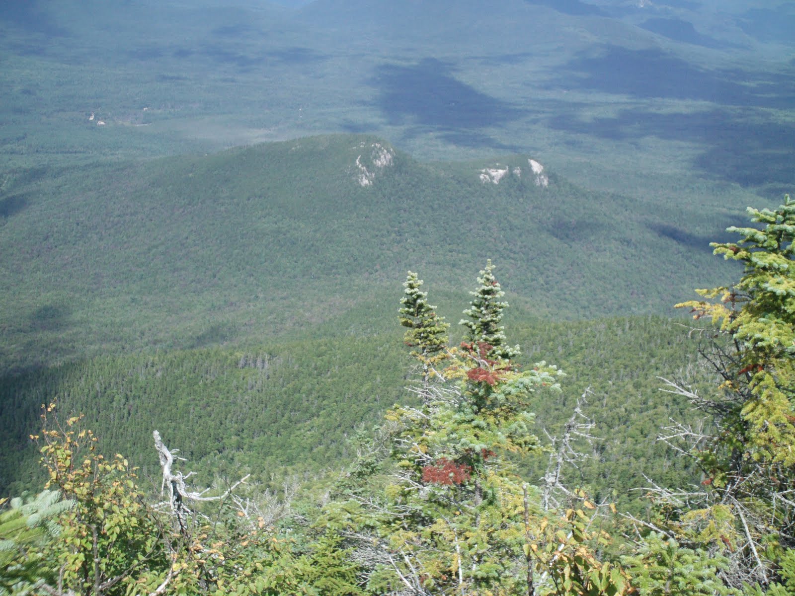
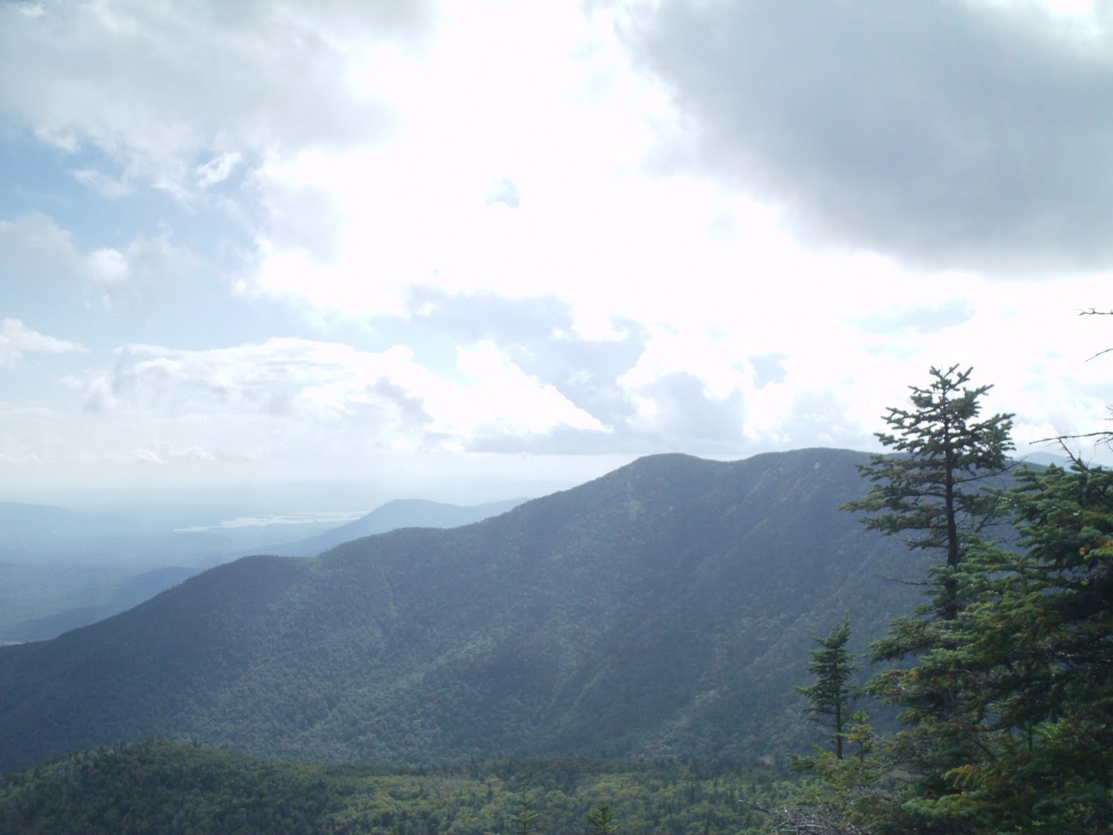
I got to the parking area around 8:30 and it was empty. Headed up Blueberry Ledge at a fast pace (for me) and stopped at the first ledge/view and had a quick snack. After some easy hiking I came to the south ledges. The day before we had over an inch of rain and the rocks were still extremely wet and slippery. If Alex was with me I would have turned around. It made for some interesting scrambling up the rocks as I could get no traction at all with my boots. At one section there are holes drilled into the rocks where wooden steps use to be. Now just the holes and I had to put 2 fingers in each hole and pull myself up with my hands as my feet alone were not able to get any reliable grip. Hoping I didn't slip and fall back down I made it up over the several sections and decided to take a break sitting on a rock that had great views of Passaconaway on the other side of the Bowl as well as panoramic views to the south. I could make out Mt. Monadnock and the Uncanoonuc's near Manchester. Between them is my house, but couldn't quite see it.
Saw 2 groups of people at the top of this ledge as they came up behind me but I left and headed back up just as they reached the top of the cliffs. The actual summit of Whiteface is (i think) marked by just a cairn in the middle of the trail in a very wooded area. It seemed like the highest point and the trail started to head down from there on so that must have been the summit. The trek across the ridge to Passaconaway was quick and easy and I saw not another person until I reached the trail junction with Dicey's Mill Trail. Ran into another solo hiker here and we ended up ascending Passaconaway not far from one another. But by this point the trail gets much steeper and my fast pace caught up with me and it was a struggle to get to the summit, but I made it and saw the sign to the true summit. Headed up into the thick scrub and followed all the herd paths around, stood on what looked like the highest point and then continued out to the nortern view which I had read about. This is the top part of a long abandoned trail but travels for about .2 miles to a spectacular view north. The weather was not great and Washington was hidden in the clouds but the view was still great, I can only imagine how nice it is on a clear day. This is a great isolated spot and descent chance of not seeing anyone else there as it is not on the main path. But I did run into someone who beat me to this spot (only 1 of the 3 parties I saw the entire day) so after some short chatting I headed back up to the summit and then down the East Loop looking for another lunch spot. Found another ledge to eat lunch on and rested for a while.
I headed back down and took Dicey's Mill trail. This section is very easy and a gradual descent all the way through some old growth forest. I read that this entire bowl has never been logged and some of the trees here are over 400 years old. I am not an expert in Old Growth Forests by any means, but these trees sure did look rather old to me. The woods were mostly all hardwood Birch trees and many extremely large trees were everywhere. There were standing dead trees as well as huge trees that had fallen years ago rotting away on the ground. I like hiking through woods like this as you know things have not changed much since the time Europeans first arrived. That is a rarity in the White Mountains (or anywhere for that matter) as even the kind of trees that grow in many place are not only relatively young, but not even the same species that inhabited the land originally.
The forecast called for a chance of thunderstorms in the afternoon and it suddenly got darker when clouds moved in over head. I had gotten my 2nd wind, the trail was pretty flat so I started jogging at a slow pace for a while. However the rain started very light and I pulled out my poncho before I got really dumped on. It did rain however I probably never needed the poncho so after it stopped, I took it off and finished the last mile or so rather dry. There are some really good camping spots along the way next to the river - not sure if you can camp there or not, but they would be great spots.
The trail ends in the back yard of someone's house! Literally, you walk out of the woods onto their driveway just a few feet from the barn and their cars. Had I started up this trail I might not have dared to find the entrance for fear of tresspassing. Both this trail and Blueberry Ledge start on private property so a big thank you to the land owners. It is probably a matter of time before new owners come in and close off access to these hiking trails. Which would be too bad, but inevitable I think. And to be honest, had I owned this particular house I would not close the trail but I would divert it away from the driveway and house a bit! After walking down their driveway there is another 1/2 mile or so on the road before the parking area. Over 12 miles with the side spur tot he view on Passaconaway and finished around the estimated book time with some tired feet! Not the greatest views but a nice hike through some old growth woods, an exciting scramble up some steep rocks and very few people - the recipe for a nice hike!
 |
| From parking area, Whiteface is in the clouds |

 |
| Some fancy stonework |
 |
| First view of Whiteface |
 |
| From south ledges |
 |
| From south LEdges |
 |
| From south ledges |
 |
| going up |
 |
| This ALOT stepper than it looks, those holes use to hold steps and is what I had to put my fingers in to pull myself up |
 |
| And up |
 |
| An idea of how steep this section was |
 |
| Looking back down |
 |
| Passaconaway over the Bowl from Whiteface |
 |
| Chocurra in distance |


 |
| Finally, something steep the trail did not go up |
 |
| Looking back down, parking area is in the rectangle field in the center of picture |
 |
| Passaconaway from Whiteface |

 |
| Summit of Whiteface (dont get excited) |
 |
| Down the bowl (all old growth birch) |
 |
| Ridge (Rollins Trail) between the mountains |
 |
| Tripyramids from Passaconaway |
 |
| I think this was Passaconaway summit, if not it was one of the other herd paths up there - walked around them all |
 |
| From view spur path on Passaconaway |
 |
| From view spur path on Passaconaway |
 |
| From view spur path on Passaconaway (Presidentials are in clouds) |
 |
| From view spur path on Passaconaway |
 |
| From view spur path on Passaconaway |
 |
| From view spur path on Passaconaway - of Mt Hedgehog |
 |
| Whiteface from Passaconaway |
 |
| Down the Bowl |
 |
| End of trail, coming out in someones back yard |
 |
| End of trail looking back at Whiteface, the trail IS their driveway |

 |
| From parking area, a little clearer now - Whiteface in distance left |
 | ||||||
Viewpoint on drive back to campsite, Whiteface is on the left and Passaconaway on the Right.
|


Subscribe to:
Posts (Atom)